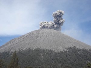
Mount Sumeru or Semeru is the highest volcano in Java, with its peak Mahameru, 3676 meters above sea level (mdpl). Craters on the summit of Mount Semeru, known by the name Jonggring Saloko.
Semeru has Dipterokarp forest hill, forest Dipterokarp Top, Montane forest, and forest Ericaceous mountains or forests.
Position of this mountain region is located between the administration and Lumajang Malang Regency, with a geographic position between 8 ° 06 'LS and 120 ° 55' BT.
In 1913 and 1946 craters Jonggring Saloka has a dome with a height of 3744.8 M until the end of November 1973. To the south, this dome bust edge craters caused lava flow leads to the southern region covering Pronojiwo and Candipuro in Lumajang.
It takes about four hours to climb the mountain peak Semeru commute. To climb the mountain semeru can be through the city of Malang or Lumajang. Terminal of the city's dismal public transport we ascend to the village Overlapping. Through again with a jeep or Truck Vegetables that are in the back of the terminal market Overlapping with the cost per person Rp.20.000, - Post to Ranu Pani.
Before we drop in Gubugklakah to obtain the permit, with the details, the cost of license Rp.6.000, - to a maximum of 10 people, park entrance Tickets Rp.2.000, - per person, per person Rp.2.000 Insurance, --
Trucks using vegetable or jeep trip starts from the Overlapping Ranu Pani, the last village at the foot semeru. Here there is a Post review, there are also stalls and cottages lodging. For the climber who bring tents charged Rp 20.000, - / when to bring a tent and a camera also is charged Rp 5,000, - / fruit. In this post, we can also explore porter (local residents to help indicate the direction climbing, raise goods and cooking). Climber can also be lodged in the guard post. Ranu Pani in the Post, there are two lakes namely Lake Ranu Pani (1 ha) and Ranu Regulo lake (0.75 ha). Located at an altitude of 2200 mdpl.
Once in the gate until the "welcome", continue to look to the left of the hill, do not follow the wide road to the gardens of the population. In addition to the usual route passed the climber, there are also shortcut the normal channels used for local climber, this path is very steep.
No comments:
Post a Comment